TOO GREAT TO LEAVE ANYMORE COMMENT

The maeslant barrier (maeslantkering), a huge storm surge barrier at the mouth of the port of rotterdam in the netherlands, is the largest hydraulic engineering structure on earth and, according to hard-fact bible wikipedia, ‘the largest moving structure on earth’. it was opened in 1997 as the final part of the delta works, an enormous project undertaken in order to protect certain coastal areas of the country from the sea after a flood in 1953 killed more than 1800 people in the area

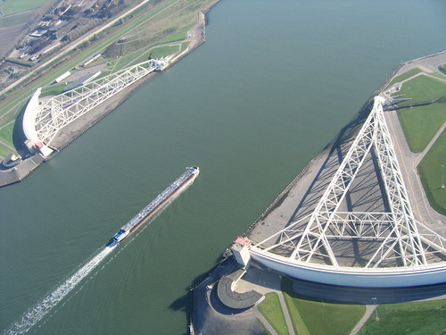
the barrier consists of 2 incredible movable gates which automatically sweep across the water, meeting in the middle of the waterway to form a temporary wall, each of the gates rotating on 680-ton steel ball joints which, with a diameter of 35ft, are also the largest in the world. the barrier’s movable design was chosen as the waterway it guards is far too valuable in terms of trade to shut off permanently: this single barrier cost $700m and has absolutely no effect on ship traffic.

a few weeks ago (november 8th) the barriers were used for the first time prior to fierce storms and succeeded in protecting the port from flooding. the gates, weighing the equivalent of 4 eiffel towers, took 30 minutes to close.

below is the barrier as seen on google maps, the direct link is here.

From Wikipedia, the free encyclopedia
Location of the Maeslant Barrier


A ship passing the barrier


Model


Closing


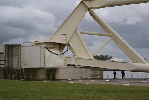
A view through the barrier
Maeslantkering là tên của 1 cửa chắn sóng biển ở Nieuwe Waterweg nằm giữa 2 thành phố Hoek van Holland và Maassluis, Hà Lan, tọa độ
 51°57′14″B, 4°09′49″Đ
  51°57′14″B, 4°09′49″Đ,có thể đóng mở khi cần thiết. Nó là một phần của Delta Works và nó là công trình di chuyển được lớn nhất trên thế giới( Ko biết có đúng thật thế ko nhỉ
  )
)(Delta Works là một số các công trình được xây dựng trong khoảng thgian từ 1950 đến 1997 ở phía Tây Nam Hà Lan bảo vệ một diện tích đất đai lớn của nước này khỏi sự xâm hại của nước biển)
Cửa van Maeslant
Kế hoạch ban đầu
Công trình Maeslantkering là một phần của dự án "Europoortkering"-và cũng là chặng cuối cùng trong Delta Works. Điều mấu chốt của dự án Europoortkering tăng cường độ an tonà cho cảng Rotterdam ,( trong đó Europoort là một phần quan trọng), cùng các thành phố và vùng nông nghiệp xung quanh. Điều này cần phải được thực hiện bằng cách gia cố cho các tuyến đê dài khoảng 50km. Trong thập niên 80, công việc này sẽ mất ít nhất là 30 năm để thực hiện và ngoài ra cũng cần một lượng tiền rất lớn.Điều này cũng có nghĩa là các thành phố thuộc về di tích lịch sử, có nơi được xây dựng từ 4 thế kỉ trước sẽ bị phá bỏ để xây dựng lại phía sau những con đê được gia cố rộng thêm kia.
Vì vậy, kế hoạch này được đặt sang 1 bên và Bộ trưởng bộ Thủy lợi Hà Lan đã tổ chức một cuộc thi trong đó các công ty xây dựng đưa ra những bản thiết kế khác nhau về một tấm chắn sóng(barrier) đáng tin cậy và...fải tương đối rẻ ^^
The storm surge barrier
This storm surge barrier had to be located in the Nieuwe Waterweg waterway. This played an important role in the planning stage of the construction, as this waterway is the main route to the port of Rotterdam, at that time the world's largest port. Therefore a barrier like the Dutch Oosterscheldekering and the Thames Barrier could not be constructed, as such a barrier would block the shipping route.
The winning plan called for two large floating gates on both levees of the waterway. A major advantage of this plan was that construction of the storm surge barrier could take place under dry conditions, in dry docks. Other advantages were that no vital parts of the barrier had to be placed under water, and maintenance of the barrier would be easy because of the dry docks. And, of course, there would be almost no inconvenience for passing ships.
Quá trình thi công
Mọi thứ được bắt đầu từ năm 1991.Vùng đất khô nơi đặt 2 cánh cửa van ở 2 bên bờ được thi công trước tiên và sau đó là phần ngưỡng cửa ở đáy cửa biển Nieuwe Waterweg. Sau đó 2 khung thép cao 22 m và dài 210 m được tiến hành .Và rồi khung giàn được hàn vào cánh cửa với chiều dài 237m. Khi dựng đứng lên, những cánh giàn này có chiều cao xấp xỉ tháp Eiffel, nhưng mỗi cánh có trọng lượng gấp đôi tháp này.Công dụng chính của nhưng cánh tay này là phân bố lực tác động lên cửa trong khi đóng về 1 điểm khớp cầu đặt ở phía sau cửa.Trong quá trình đóng mở, khớp cầu này cho phép cửa van có thể di chuyển tự do dưới ảnh hưởng của nước, gió và sóng. Nó làm việc như một khối cầu và phần lõm để lắp khối cầu này, kiểu như khớp ở vai và hông trên cơ thể chúng ta vậy. Các khớp cầu này được chế tạo tại Séc và Skoda Works(?). Đây cũng là khớp cầu lớn nhất trên thế giới với đường kính 10m,nặng 680 tấn.Quá trình thi công tấm chắn sóng này cần đến 450 triệu EURO trên tổng 660 triệu EURO của dự án Europoortkering
Một mô hình của Maeslantkering đã được xây dựng tại khu trưng bày mô hình Madurodam. Mô hình này mất 6 tháng để thực hiện( kể cũng hơi lâu nhỉ
Maeslantkering trong quá trình vận hành
Vào ngày 5/10/1997, sau 6 năm xây dựng, nữ hoàng Beatrix cho phép chiếc barrier đi vào hoạt động. Chiếc barrier này được nối liền với 1 hệ thống máy tính tự động có kết nối với các dữ kiện về thời tiết và mực nước biển. Trong điều kiện thời tiết bình thường, 2 chiếc cửa được bảo dưỡng trên khu vực đất khô 2 bên bờ và 360m khoảng không còn lại của cửa biển vẫn đủ thuận tiện cho tàu bè qua lại.Nhưng một khi có đợt sóng cao trên 3m được dự báo sẽ xảy ra tại Rotterdam, chiếc barrier này sẽ tự động đóng lại.
4 tiếng trước khi lệnh đóng barrier bắt đầu, tất cả các tàu bè ra vào sẽ được cảnh báo. 2 tiếng trước khi đóng, hệ thống giao thông thủy tại Niewe Waterweg sẽ bị ngưng lại. 30 phút trước khi đóng, 2 vùng đất khô dưới 2 cánh cửa 2 bên bờ sẽ được làm ngập.
Sau khi 2 cánh cửa bắt đầu nổi và 2 chiếc " locomobiles" đưa 2 cánh cửa này hướng về phía nhau.Khi khoảng không giữa 2 cánh cửa là 1,5m, nước được đưa vào bên trong những lỗ rỗng của 2 cảnh cửa nhờ đó chúng được nhấn xuống đáy cửa biển. Đáy biển trước đó đã được đào xuống tạo thành những khe lớn, nhờ đó 2 cánh cửa khi chìm xuống sẽ ăn khớp với những khe này. (Chính những khe này ngoài việc làm cho nước không len qua được ra ngoài còn làm cho kết cấu thêm phần ổn định khi phải chống đỡ áp lực tĩnh và động từ phía nước biển) .Trong trường hợp chiếc cửa phải đóng trong 1 thời gian dài, mực nước phía sau cửa van sẽ dâng lên( Vì nước nó phải chảy từ sông đổ ra biển chứ không thì đổ đi đâu bây g^^) các khe rỗng trên barrier này sẽ " 3 chìm 7 nổi"^^ tức là có 1 phần ngập nước còn phần kia thì không, nhờ đó lượng nước dư thừa sẽ được chảy ra biển , rồi sau đó tất cả sẽ lại được nhấn chìm 1 lần nữa. Mọi thứ đều được lập trình và chạy hoàn toàn bằng máy tính.
. In case the gates will have to be shut for a prolonged period, so that the waters of the Rhine starts rising behind them, the gate hollows are partly emptied and floated, so that excess river water runs out to sea, before they are submerged again. The decision-making algorithm that sequences storm surge-triggered events in the Maeslantkering is run entirely by computer.
The Maeslantkering is expected to be closed once every ten years due to a storm surge. With the rise in sea levels the storm surge barrier will need to close more frequently in 50 years time, namely once every five years. In its first ten years of operation the barrier was never closed due to a storm. There was one incident when a storm surge of 3 meters was predicted and the protective sequence was commenced. However, during the course of the storm, predictions were revised to a 2.99 m surge and the computer cancelled closure. Eventually the surge passed harmlessly and the waterway remained open. During the evening of November 8, 2007 the barrier was closed due to a storm surge for the first time. The barrier is closed for testing once a year, usually in September or October, just before the beginning of the storm season in November.
The Calandkanaal (Caland canal), located just south of the Nieuwe Waterweg and visible in some images on this page, is protected by the much smaller Hartelkering storm surge barrier. This barrier is constructed some 5 kilometers further inland.
The software that drives it is written in C++ and consists of 200,000 lines of code for the operational system and 250,000 lines of code for the simulation systems[1]
The barrier is designed to withstand a storm that has an occurrence of only 1/10,000 per year (based on the climate at the time, but this may have to be adjusted for the climate change).
8 November 2007 storm
In order to test the barrier in actual stormy conditions, the water level threshold at which the barrier will start the closing procedure had been lowered from 3.0m over NAP to 2.6m, for the duration of the 2007 storm season. On 8 November 2007 a storm from the north-west hit the Dutch coast. A storm surge, high enough to start the barrier's closing procedure, occurred. The barrier was closed due to a storm surge for the first time since its construction[1]. As the Oosterscheldekering and Hartelkering storm surge barriers were also closed, the entire Dutch coast was protected against flooding for the first time since 1976. At 22.00h local time (CET), Dutch TV brought the news that maritime traffic on theNieuwe Waterweg was shut off. The closing procedure of the Maeslantkering started at 23.10h. The barrier was completely closed at 01.00h and was reopened on 9 November around 18.00h.
Nguồn từ http://tainguyennuoc.vn


Đăng nhận xét